Karten
http://www.hcl.harvard.edu/libraries/maps/exhibits/baroque/introduction.cfm
via
http://schmalenstroer.net/blog/2012/02/landkarten-des-barocks/

via
http://schmalenstroer.net/blog/2012/02/landkarten-des-barocks/
noch kein Kommentar - Kommentar verfassen
noch kein Kommentar - Kommentar verfassen
Wolf Thomas - am Samstag, 7. Januar 2012, 14:10 - Rubrik: Karten
noch kein Kommentar - Kommentar verfassen
... "mit der sehr gelungenen Website "Des villages de Cassini aux communes d'aujourd'hui". Die Navigation erfolgt über die "Carte de Cassini" oder über den Namen eines Ortes. Das Dossier über einen Ort enthält u.a die Entwicklung der Einwohnerzahlen und ist downloadbar:" http://cassini.ehess.fr/cassini/fr/html/index.htm
Via Mareike König, G+

Via Mareike König, G+
noch kein Kommentar - Kommentar verfassen
noch kein Kommentar - Kommentar verfassen
http://bibliostoria.wordpress.com/2011/09/06/arquivo-digital-de-cartografia-urbana/
Die Tipps dieser Quelle sind meistens gut, aber dieses portugiesische Angebot ist bei näherem Hinsenen (wenn man sich kostenlos registriert hat) Schrott. Die Suche ist nicht benutzerfreundlich und sieht man dann nach längerem Blättern Bilder, geht die Zoomfunktion nicht.
Die Tipps dieser Quelle sind meistens gut, aber dieses portugiesische Angebot ist bei näherem Hinsenen (wenn man sich kostenlos registriert hat) Schrott. Die Suche ist nicht benutzerfreundlich und sieht man dann nach längerem Blättern Bilder, geht die Zoomfunktion nicht.
noch kein Kommentar - Kommentar verfassen
http://press.uchicago.edu/books/HOC/index.html
The first volume of the History of Cartography was published in 1987 and the three books that constitute Volume Two appeared over the following eleven years. In 1987 the worldwide web did not exist, and since 1998 book publishing has gone through a revolution in the production and dissemination of work. Although the large format and high quality image reproduction of the printed books (see right column) are still well-suited to the requirements for the publishing of maps, the online availability of material is a boon to scholars and map enthusiasts.
On this site the University of Chicago Press is pleased to present the first two volumes of the History of Cartography in PDF format.
noch kein Kommentar - Kommentar verfassen
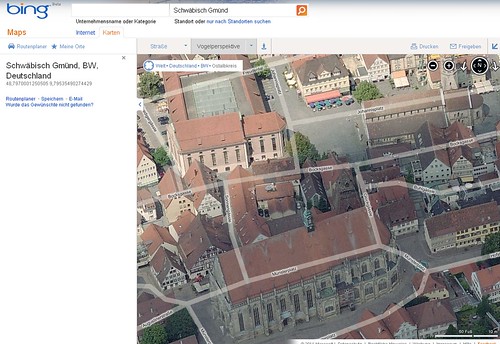
Stadtmitte von Schwäbisch Gmünd
Via http://mannigfaltigkeiten.twoday.net/stories/29758529/ (natürlich Ravensburg)
Via http://mannigfaltigkeiten.twoday.net/stories/29758529/ (natürlich Ravensburg)
noch kein Kommentar - Kommentar verfassen
Wolf Thomas - am Mittwoch, 22. Juni 2011, 20:01 - Rubrik: Karten
noch kein Kommentar - Kommentar verfassen
noch kein Kommentar - Kommentar verfassen